


Wildland 52 Mountain Race & Backyard Ultra
Mountain Race benefitting Wildland Firefighters and their families in need
WOOHOO!!
I’m so excited to announce we are planning the SECOND annual Wildland 52k Ultramarathon!
When: September 14, 2019, 6:30am-6:30pm
Where: Jemez Springs, NM
Who: Anyone who has completed a mountain trail ultramarathon. Well, the first 30 to sign up, at least!
FAQ:
Q: When does registration open?
A: March 15, 12:00am
Q: What is the cut-off time?
A: 12 Hours to finish the race. There is a 5 minute allowance if you get a massage on Cerro Pelado. Hahaha Yep. I’m serious.
Q: What is the sports drink?
A: We’re hoping Tailwind again! You are welcome to bring something else for your drop bags, but we won’t be able to offer any sports drink other than the sponsoring provider.
Q: Will there be a shorter race?
A: 21 Miler! The “big loop” of the 52k course.
Q: Will there be a relay?
A: We are looking into this; however, if we do, it will be limited to first responders only (Firefighter, EMT or Police; may be combined).
Q: Is the course the same?
A: We are hoping to be able to keep the same course, but may have to change the start due to it being on private property. If it must be changed, it will start and finish in the same location to make it simpler logistically for runners. We will do all we can to keep the same amount of elevation, however; if we have to decide between easier or harder, we will go with “harder”. We should know soon if there is a change.
More details to come soon!
Today marks a heavy anniversary… and one of the driving events behind the creation of the Wildland 52.
These men, the men of the Granite Mountain Interagency Hotshot Crew worked on two major fires in the Jemez Mountains, the 2011 Las Conchas and the 2013 Thompson Ridge. They were key in the development of a Structure Protection Plan for what we called “VDI”. VDI was a name given to the general Vallecitos de Los Indios area including Sierra de Los Pinos, Vallecitos and Ruby Holt tract (Bennet Lane and Sky High Way). Their last assignment before perishing 6-30-13 in the Yarnell Hill fire was here, in our beloved Jemez Mountains.
They, and those who loved them, paid the ultimate sacrifice that day. It is our hopes that the Wildland 52 will help to raise funds to support two invaluable organizations that support the Wildland Community; just a small token of our honor, our love and gratitude.
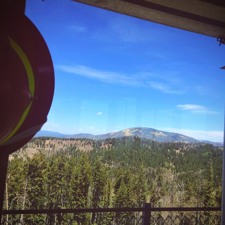
* Looking north, Redondo Peak backdrops the ridge of Los Griegos Mountain from the Fire Lookout tower on Cerro Pelado. Runners will ascend Los Griegos from the west, run the ridge, then drop into the saddle and ascend to the Fire Lookout.
One of my favorite sections of trail starts with a climb up a dozer line, which I was told was cut last year during the El Cajete fire; it’s rough, loose and steep enough that it caused the course to change direction. Flanked in Ponderosa, Fir and Aspen the wide path is a rocky scar with drainage berms; wildflowers are flourishing in the turned soil. It nearly crests the ridge before giving way to single track over narrow ridge of rock and shrubbery. The rock is still stained coral from the slurry drop and though the steep face to runner’s left is covered in darkened trees burnt in that fire; the right side is more sloping and green and healthy. I felt like an excited kid as I steeped out on it, even more so when I found the old call box nailed to a tree; the phone that the fire lookout and patrol rangers used to call the ranger station in the Jemez Springs village is gone, but remnants of the phone line remain. An abandoned chain left from a sawyer hangs nearby, and a summit register that I didn’t notice my first trip up holds the names of two fire crews who worked the El Cajete and Los Conchas fires. It may sound silly, but given the fact that this was not the original course and the purpose of the race, these finds had me on cloud nine; no one can make me believe I was not supposed to find these items and route the course this way!
The trail follows part of the old “high line” route that the fire lookouts traveled on daily patrols by foot or horseback; runners will drop off the ridge to the saddle on the south, then ascend to the top of Cerro Pelado, where they will find aid and refreshments at the base of the current Fire Lookout. After a pause to refuel and take in the views, they will descend the steep, grassy slope below the powerlines to Keddy Lake (Ranger Keddie used to man the fire look out, which also was where supplies would be brought for rangers at other lookouts farther south; from what I was told, he dug the pond for the horses to water). From here runners will leave the high-line trail and head north through a beautiful mountain meadow, surrounded by fir trees and aspen, on a gentle descent on wide, runnable paths covered in short grass, flirt with the edges of the El Cajete scar and take in spectacular views of the older Los Conchas burn area and Valles Caldera.


*clockwise: climbing up the dozer line on Los Griegos; Los Griegos Ridge line (north side burned during El Cajete in 2017, while the south side was not); Ridgeline still painted from the slurry drops and a sawyer’s chain remains; Fire lookout can be seen on the summit of Cerro Pelado from Los Griegos.
The course profile of the proposed of the Wildland 52! There’s approx. 8 miles before the main loop that are up for debate, as it is partially on private property (lawyers are reviewing it). Initially, this course shown below was the add on to the original 52k course, in efforts to make it 52 miles. But, after extensive exploring and many course adjustments I’m in LOVE with this section of the race and it’s now the core of the 52k!
Why? It’s a gorgeous slog. It’s Type 2 Fun at it’s finest. Steep ups and downs (no weak ankles or fragile tailbones, please), super technical terrain requiring quick-on-your-toes footing that gives way to wide grassy meadows that will make you want to whirl and sing your way through them. Not to mention the best views in the Jemez, and SO MANY unexpected historical surprises that tie this course to wildland fires and the wildland firefighting community. This IS Wildland!!!

*This elevation profile is for the proposed course. The map is not being provided due to a two-mile segment on private property; we are awaiting approval from the land-owners and their lawyers. If the deny our proposal, there is an alternate route planned that will provide a similar profile, but start with a descent and then a climb.
Thank you for your patience!
